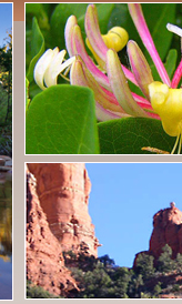
Nearby Sedona Hiking Trails
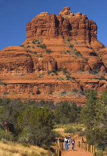
The Bell Rock Pathway
The Bell Rock Pathway is a 3½ mile trail linking the Village of Oak Creek and Sedona. Along this pathway you'll enjoy fantastic views of Bell Rock, Courthouse Butte, and other landmarks. Most of the pathway has a wide, hard surface, but there are some steep hills too. Some places around Bell Rock are rocky and rough. (You can also mountain bike on this trail).
Length: 3.7 miles; rating-easy/moderate; season-all year; hiking time-2.5 hours
Location: From the junction of Routes 89A and 179 in Sedona, take 179 south 3.6 miles to a paved turnout and trailhead parking on the left (east) at milepost 309.8, 0.2 miles south of the entrance to the United Methodist Church for the northern trailhead.
Broken Arrow Trail
Broken Arrow Trail is an easy hike on a good trail with great red rock scenery. Begin at the signed trailhead which will direct you across the jeep road to the trail. After 200 feet, the trail bears left (south) and soon crosses a ledge at the foot of Battlement Mesa. At 0.6 miles, look for the fence around Devil's Dining Room Sinkhole 100 feet to the left and downhill.
Explore, then return to the trail and continue as it gradually climbs to some scenic red rock outcrops beside Twin Buttes on the right. Continue to the end of the trail at Chicken Point at 1½ miles where there are more great views. . At ½ mile from Chicken Point, take the short side path to the right signed for Submarine Rock. Walk this interesting formation, and then return by the same path to the main trail. Continue north to complete the hike of about 3½ miles (roundtrip including Submarine Rock).
Length: 1.5 miles; rating – easy; season – year-round; hiking time – 1-2 hours round trip
Location: From the junction of Routes 89A and 179 in Sedona, take 179 south 1.4 miles to Morgan Road on the left (east). Go 0.6 miles to the end of the pavement, cross the cattle guard and continue for another 80 yards to trailhead parking on the left.
West Fork Oak Creek
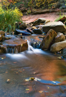
West Fork Oak Creek There are a number of reasons why West Fork is the most popular trail on the Coconino National Forest. There is a pleasant little stream that ripples along the canyon floor as you hike it where you can look up at the dizzying cliffs that tower above. In the spring, it is particularly beautiful when migrating songbirds decorate the trees and delicate wildflowers are blooming brilliantly. The fall is haunting with nostalgia when pastel leaves float in clear reflecting pools under a canopy of solid color. If you come in the winter, you are likely to see icicles hanging from red rock overhangs and wisps of snow. As a matter of fact, you'll probably find many memorable and unique reasons to be here every time you visit.
As for the trail itself, it's an easy stroll, but you do have to cross the stream in a number of places. Usually, that involves negotiating a few strategically placed stepping stones or taking a couple of steps in shallow water. The trail is marked for the first three miles, but there is more if you want to continue. Eventually the pathway ends and you will be forced to hike in the stream bed as you continue into the Secret Mountain/Red Rocks Wilderness. If you choose to travel all 14 miles from one end of the canyon to the other, plan to do a lot of wading and boulder hopping, and perhaps even some swimming.
Mornings and weekdays are best as there are fewer fellow hikers.
Length: 3 miles; rating – easy; season – all year; hiking time – 2-3 hours round trip.
Location: Drive 89A north 9.5 miles from Sedona to about halfway between milepost 385 and 384. The trailhead is on the west side of the highway down a paved lane that leads behind a few creek-side houses. The best place to park is at the Call O' The Canyon day-use area. |